fbpx
Donate Newsletters

What Coal Trains Mean for Seattle Traffic

In June, Sightline wrote about the ways that coal trains would impair traffic in Seattle. We identified specific streets—several of them critically important to freight mobility—that coal trains would shut off periodically. So we were very pleased yesterday to see the City publish a sophisticated new analysis by traffic management firm Parametrix that confirmed our … Read more

How Coal Is Already Congesting Washington’s Railways

Washington’s rail system is congested in places. Adding dozens of coal trains each day, without also big new capacity improvements, could cripple the system with gridlock. All that is common knowledge. Less well-known is this: coal shipments are already causing problems.

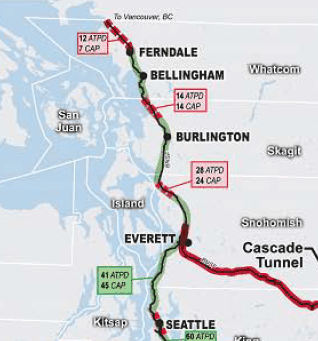
To understand what’s going on, it’s useful to zero in on the northwest portion of the state’s railway system. Here’s a close look at northwest Washington, the area most directly affected by Cherry Point coal exports:

This Cambridge Systematics map from 2006 is the most recent comprehensive analysis of the state’s rail system. The green on the mainline between Everett and Canada indicates adequate capacity, but the numerous red dots indicate hotspots of local congestion that plague the system.

What’s happening on the ground there now? In May 2011, the regional rail experts at the Cascadia Center produced the “Cross-Border Freight Rail Improvement Study,” for the Whatcom Council of Governments (along with a companion volume “Cross-Border Passenger Rail Improvement Study). It turns out that things in the area are not going smoothly.

There are a variety of reasons, but one reason is coal.

Read more

Coal Trains and Rail Congestion

Is Washington’s railway system congested? Yes and no.

Would it become congested if 100 million tons of coal per year were moving along the rails to Washington ports? Almost certainly.

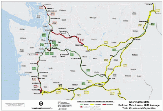
To understand the basics of rail congestion in Washington, take a look at this map showing the state’s main railway lines color coded by their level of congestion.

This map comes from the “Statewide Rail Capacity and Systems Need Study” conducted in 2006 by Cambridge Systematics for the Washington State Transportation Commission. It’s the most recent and comprehensive analysis of the state’s rail system.

Washington has a single north-south railway “backbone” on the west side of the mountains, running from the Canadian border to Vancouver, Washington. The green colors indicate where it is operating below its “practical capacity,” but the red colorations indicate bottlenecks and other congestion hot spots, which occur up and down the line. (Please see the “notes” section at the end of this post for an explanation of terms like “practical capacity.”)

Read more