Search Results
-
Fuel's Gold
No regional angle here, really, but astonishing nonetheless—according to a new report by Environmental Defense, American cars and trucks gobble up about 45 percent of the world’s highway fuels. Time and again, I’ve heard that the United States accounts for less than 5 percent of the world’s population, but consumes about a quarter of the world’s total resources (lumber, minerals, energy, etc.). When you do the math, this means that...Read more » -
Lonely Hearts Club: Still Growing
Fascinating report on diminishing social ties in the US. Americans now report having only 2 close friends, on average, and 1 in 4 say they have no one to discuss important matters with. [The study] found that men and women of every race, age and education level reported fewer intimate friends than the same survey turned up in 1985. Their remaining confidants were more likely to be members of their...Read more » -
Two Roads Diverged
A couple of notable news stories BC got lost in the shuffle of a busy week. First up, there’s this news from the Vancouver Sun: apparently, some regional planners are taking a skeptical look at the so-called Gateway Program, which would expand the highway system in the lower mainland. According to UBC professor William Rees, the project will foster low-density suburban development—an increasingly dicey prospect in an era of rising...Read more » -
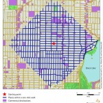
Map of a Compact Community: Walkability within One Mile
A one-mile walk in this urban neighborhood, Seattle’s Phinney Ridge, takes you through a gridlike street network with a mix of residences and businesses. This walkable design puts stores and services within a short walk of many homes. (The walkability maps and information presented in Cascadia Scorecard 2006 were developed by Dr. Lawrence Frank, Bombardier Chair in Sustainable Transportation at the University of British Columbia, and colleagues Dr. James Sallis...Read more » -
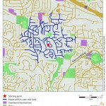
Map of a Suburban Community: Walkability within One Mile
Neighborhoods with cul-de-sacs and winding streets, such as this one in Bellevue, WA, have few shops and services within walking distance.Read more » -
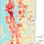
Map of Walkable King County, WA
In King County, Washington, compact city and town centers promote walking, while sprawling suburbs discourage it.Read more » -
Cascadia Scorecard 2006
The third edition of the Cascadia Scorecard examines the connections between urban design and health risks such as car crashes, obesity, and physical inactivity. It also identifies ways we can create communities that favor health by making it easier for people to get out of their cars and get more connected.Read more » -
Is Your Commute a Killer?
That’s the Vancouver Sun headline from reporter Chad Skelton’s front-page story on Cascadia Scorecard 2006, Sightline’s third annual progress report on the Northwest. The Seattle P-I also covered the book, in the paper’s Health & Fitness section, as did the Surrey Leader in BC; the Daily Journal of Commerce in Portland and the DJC in Seattle (both require subscriptions to access content); Oregon’s KTVZ; and a slew of radio stations....Read more » -
This Book Was Made for Walking
Editor’s note: Cascadia Scorecard 2006 was just released! This year’s focus is on the many connections between community design and health. Go to the press page for a full press kit and regional scorecards, look at new maps (pdf); read about our top solutions for health (pdf), or order or download a copy. And please let us know if you hear or see media coverage about the book (email elisa@sightline.org)....Read more » -
Solutions for Healthier Communities
Individuals and institutions can take simple steps to create compact, complete communities that enable residents to get around without a car and encourage physical activity and connections among neighbors.Read more »


