Lately it feels like Northwest wilderness protection can’t catch a break. Not only has it proved damnably difficult to pass even popular new wilderness designations, but much-loved trails and access roads are gettingpummeled by winter storms. Routinely it seems.
But maybe—just maybe — there’s a golden opportunity amidst the storm wreckage. Maybe we’ve been given a cheap and easy way to expand our wilderness areas. After all, a washed-out or heavily-damaged road means more than just frustrated hikers: it also means a lot more wild country.
That’s because some of the worst storm-related fury is actually the aftermath. Chronic underfunding, mismanagement, and heightened concern for the environment often makes rebuilding access roads to trails prohibitively expensive or extremely controversial. In fact, Washington is a good example. The mangled Dosewallips and the Stehekin River Roads have probably been the most contentious locations. But also the Cascade, Suiattle, and White Chuck River Roads, plus the Mountain Loop Highway near Barlow Pass. Oh, and the Queets, which has been out of commission for who knows how long. And I hear the the South Shore Quinault is out again. That’s just some of the major stuff: it doesn’t include the welter of smaller forest roads that provide valuable access to lesser known trails and peaks.
Trailheads are part of a large share of my weekends, so I certainly appreciate the ready access that we Cascadians are blessed with. But I’m conflicted too. Despite Washington’s comparative wealth of official wilderness areas—a greater share of our land than any state other than Alaska and California—I’ve long wish we had even more. But too much of our wilderness is barren rock and ice terrain; it’s lovely to look at, but it’s not habitat-rich like low elevation areas are. And that’s where the road-destroying storms may have a silver lining.
Exhibit A is the ever-controversial Dosewallips River Road.
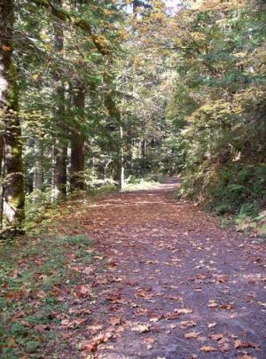
Nowadays, the Dose Road ends 5 miles short at a gigantic washout. Once you’re out of the car, you skirt the washout in a quarter mile or so of short switchbacks and then descend back to the road. From there it’s a lovely well-graded 5 mile walk (pictured above) to the campground at road’s end, which for the last couple of years has been a luxurious “backcountry” destination. It’s got picnic tables and fire rings nestled under big leaf maples beside the river. The trail proper then strikes out into the heart of Olympic National Park.
So, there’s an optimistic take on the Dose washout: we didn’t lose 5 miles of road so much as we gained 5 miles of trail. And the former road bed is a “trail” that mountain bikes can use too, which are rightly verboten on actual trails in national parks.
Maybe I’m being Pollyana. Some people complain — legitimately — that because of the Dose washout Lake Constance is no longer a dayhike for most folks. Similarly, Dose Meadows and Honeymoon Meadows are now multi-night excursions for all but the uber-fit. And climbing Mount Constance is now even more grueling. (On the other hand, some of these places were being loved to death. And like Glacier Basin above the now semi-closed road to Monte Cristo, these spots will gradually recover their health when spared from armies of tenderfeet.)
So here’s my modest proposal: since we don’t have the money to fix all the roads that keep getting washed out, let’s stop trying. But let’s also create a designation for these newly-roadless areas, a sort of Wilderness Lite.
Mountain bikes and horses would be welcome in Wilderness Lite. And campfire policy could be more liberal than it is in the backcountry. By providing a place for these heavier-impact uses, it might reduce the encroachment of them in true designated wilderness areas.
Wilderness Lite would have ecological benefits too. Roads spread invasive species and their erosion damages rivers. By allowing nature to selectively phase out certain roads, we could be helping to restore ecosystems. Even better, almost all of the frequently washed-out roads are in low-elevation river valleys, the kind of places with old growth forests and salmon streams—the very places that are under-represented inside current wilderness boundaries.
In truth, we may not have much of a choice. Many of the best climate models predict that the Northwest is going to see more floods of the kind that wreck havoc on forest roads. If the recent winter floods weren’t instances of climate disruption, then they were at least good previews of what we’re likely to see. It’s probably going to get even harder to keep up—and we’re already behind.
Deciding on a forest road triage approach—sweetened by a new Wilderness Lite designation—might free up resources to protect our highest priority roads and trails. In a way, Wilderness Lite honors the legacy of conservationists like Supreme Court Justice William O. Douglas, who argued that a growing population would require more wild places. If we’re smart, future generations of Northwesterners may inherit a world with more deep wilderness—plus more Wilderness Lite — than we enjoy today.
I borrowed the title of this post, and some of the thinking, from an article in Crosscut by Bill Schneider, a writer for New West.





Snoqualman
I couldn’t agree more with Eric de Place’s comments. Amid all the gnashing and wailing about “lost access” from hiker groups and certain prominent newspaper columnists who should know better, why is it that so few observers have noted what is so obvious – that every impassable road means that wild country has grown that much bigger?I have walked the Dosewallips road that de Place mentions, and it is a wonderful walk, so much nicer than what it was before: just another road. It took fifteen years of work, but the Forest Service was recently convinced to give up on the upper 8 miles of the Middle Fork Snoqualmie road. Again, a miserable, potholed, forgettable road is now a great walk. I’d urge anyone who is interested to check out the Whitechuck road, washed out in 2003, and now transformed by our wonderful wet climate into something one could call “magical.” I just hope we can keep the bulldozers from taking it back, as the Forest Service says it plans to do, cheered on by the “access” fanatics.It’s amazing how quickly an ugly road can turn into a beautiful trail in our climate. Generally, just one year does the trick. In ten years, you could swear it had never been a road.Fortunately, there are some people out there who have realized this. Check out: http://www.wawatersheds.blogspot.com/A nascent effort, to be sure, but one that will surely grow. With the decline of the oil age coming very soon, and the era of lavish roadbuilding subsidies now just a memory, there is no way that the thousands of miles of roads carved across NW mountains can be maintained. And without constant maintenance, any road in our climate is a temporary road.It’s unfortunate that so many (but not all,) of the organized hiking groups have chosen to look upon this as a disaster rather than an opportunity. Evidently they are reluctant to let go of the mindset that regards a hiking experience as driving deep into wild country to a short trail leading to some high country beauty spot. Me, I’d rather hike a pleasant lowland road / trail through re-wilded country. I’m content to save the high meadows for when I have more time to reach them, and when I do, they will be all that much wilder. And there will always be some roads that penetrate wild country deeply for those whose hiking experiences have to be the “quick fix” kind.Regarding “Wilderness Lite,” it’s an interesting concept, and one that has been much thought about. One difficulty is that once such a designation was created, it might be very difficult to ever get any more of the real Wilderness. Given political realities, everything might default to the “easier” designation.But why worry about even putting a formal name on it? These are public lands we are talking about, after all. We have managed to greatly reduce the subsidized giveaway of trees from public lands, a giveaway that left us with all these collapsing roads. Hopefully we will in future drive a final stake through the heart of public lands logging. Almost all the really good timberlands are on private lands, anyway. We will always have wood available. I look forward to the simple designation “National Forest” being good enough to protect those lands. We can continue to sort out what should or shouldn’t be formal Wilderness. That Wilderness can be surrounded by regular National Forest, safe from logging, but easier to build new trails into, or convert old roads into new trails. It’s already happening very close to Seattle, in places like the Skykomish, with the pending Wild Sky Wilderness, and in the Middle Fork Snoqualmie, where a valley that not so long ago was a “mountain slum” with wild shooting, garbage dumping, wrecked cars and meth labs is well on it way to being “taken back” and transformed into a safe, attractive place. Let’s hope those trends continue and spread to other places. Those big green areas on the map will hopefully continue to get bigger, and to take in the rich, productive lowlands which have too often been missing from them.
Eric de Place
I can’t believe I forgot to mention the Middle Fork Snoqualmie! That’s surely the best example of a smart and successful road-to-trail transformation. It may have paved the way—har, har—for the recent proposed expansion of the nearby Alpine Lakes Wilderness. Now, what about Wilderness Lite* protection for the valley itself? *Re-branding desperately needed.
Snoqualman
Well, we have wrestled with the idea of a National Recreation Area or some such for the Middle Fork Snoqualmie – I’d be pleased as punch if we could just get it withdrawn from mineral entry.One other important point: We cannot afford to simply walk away from most of these old roads. Most of them, if left to Nature, may regreen nicely, but each and every culvert or stream crossing, and some unstable fill areas, are ticking time bombs. We don’t need to do a Cadillac decommissioning on every mile – we’ll never have the money, anyway, – but a big part of the triage process needs to be identifying those potential problems and dealing with them before we walk away.Often those problems don’t become evident till 10 or 20 years later, when a big blowout can suddenly happen. Congress recently appropriated $40 million to address the problem, which is at least a start. Let’s hope the Forest Service doesn’t use it simply for business as usual. If we are ever going to see salmon recovery around Puget Sound and beyond, we have got to fix the problem areas on those old roads before it’s too late.
Eric de Place
Very good point there: untended closed roads can erode with serious ecological consequences. So in a few spots we’d need some kind of investment in “decomissioning”.
Morgan Ahouse
For me, decommissioned roads, like FS56 in the MF Snoqualmie watershed, tend to be depressing hiking experiences, because they go through previously harvested lands. I don’t know of a single logged area that even remotely resembles a native one. yuk! Quartz creek or even the roads on the north side of Granite Mt are icky, though the end of Quartz Ck has a wonderful lake with an approach through beautiful old growth.I would love to see, and would certainly volunteer to help, decommissioned roads get converted to trails suitable for biking or running. That means small gravel and/or duff. For me, the sole utility of service roads is to afford quick passage past the secondary and tertiary growth. Maybe, just maybe in 45 years when I’m making my last rounds, these places will be worth walking through.
Charles S.
I’m always been curious at what exactly they mean by ‘cost of damages’ when they speak about public wilderness areas. Is it just transportation infrastructure and buildings? Or, do these bureaucracies have some means of giving monetary value to standing trees? If so, don’t they realize nature happens? This is besides the point that putting a dollar value on everything is rather limiting, as it’s capitalism-speak… quantifying things rather than qualifying them. I always find it befuddling when someone tries to assign a monetary value to a hike in the woods.Good piece, thanks. The long wait for these roads and the surrounding areas to be recaptured by wildness would be worth it.
Rod
DECOMMISSIONING is the key issue that must be considered if one opposes reopening the Dosewallips Road. The mountainside from Mount Constance to 5050 Pass on the Tunnel Creek trail drains across this road. There are two bridges (Constance and Bull Run Creeks) and dozens of culverts need to be removed, and the streambeds recontoured and restored at each to prevent erosion. Of the 5 miles of road above the washout, about 4 miles are INSLOPED to ditches that drain across the road through culverts; the roadbed should be OUTsloped to shed water rather than collect it. Steep cuts and fills (present at most turns in the road) need to be removed. This requires heavy equipment: a tracked excavator, bulldozer and dump trucks. The Dose Road would have to be reopened to get this equipment in. So it is more work to reopen, decommission and close the road that to simply reopen it. In 2004, the Western Federal Lands Highway Division estimated it would cost $170,000 more to convert this road to trail than to simply reopen it. This is not a trivial issue. Yet it is never mentioned by opponents of the Dose Road, perhaps because there is no practical decommissioning plan, nor any source of funding for it?Olympic National Forest expects to release in March 2008 their Draft Environmental Impact Statement for reopening the Dosewallips Road on a shelf above the washout. Decommissioning is not a practical alternative, and is not considered in the DEIS. To receive a copy of the DEIS, contact Tim Davis ONF 360-956-2375 or email comments-pacificnorthwest-olympic@fs.fed.us with “Dosewallips DEIS” in the subject line, and request DEIS Summary (25 pages) or Full DEIS (320 pages).
Rod
As a hiker, yes we have gained a “luxurious ‘backcountry’ destination”, the Dosewallips Campground. But we have lost more than we have gained. We have lost equivalent (5 to 7 mile) access to Camp Marion on the main fork Dosewallips, and Big Timber and Diamond Meadows camps on the west fork. Each one of these has two bear wires, a latrine, a stock area and a full acre of campground area with more than a dozen well-separated tent campsites. And today, each of these are littered with windfall branches, evidence they have been largely deserted since the 2002 Dose Road washout. We hikers have lost more than we have gained. National Parks exist not only for us hikers. Dosewallips Road is the only motorized access to Olympic National Park for a distance of 80 miles along US Hwy 101 between Staircase and Deer Park. Only roughly 1% of Park visitors hike into its backcountry. Our parks will not recieve the public support essential to their maintenance if most of the public is excluded.
Morgan Ahouse
Excellent and informative points. thanksThe Quilcene and Grey Wolf are accessible by car, too, though hardly as easily as the Dose.
Rod
Quilcene and Gray Wolf do not provide motorized access to the Park, but to the Olympic National Forest. So those trailheads have no staffed Ranger Station that provides trail information and permits, no 30-space car campground, no showers and restrooms, and no Terrace Nature Trail, as does the Dosewallips. One can hike into the Park from them… although its a long hike from the Quilcene (Marmot Pass, Home Lake, Constance Pass) which leads to… the Dose trailhead! Same for the Gray Wolf… most loops would lead to the Dose TH.There is no site on Federal land for a replacement CG/RS below the Dose Road washout. (Former Steelhead CG is in floodplain, and the Chinook Recovery Plan is to remove the riverbank armoring and reopen it to the river.(1)) No funds are available to purchase private land or build a replacement campground below (east) of the ONF boundary. So it is irreplaceable and is a real loss… until the road is reopened.Our National Parks do exist for car campers, such as families with young children, not only for us hikers (although the most vocal opposition group disagrees, and advocates banning all vehicles from Olympic National Park… and there is a certain romance to that).(1) “Restore channel complexity at Steelhead Campground through addition of key wood pieces, removal of sediment plug at top of enhancement pond, road bed and 200 meters of low riprap.” NMFS Chinook Recovery Plan page 311.
Rod
As a footnote, the environmental issues have been discussed at Northwest Hikers and an attempt is made to analyze the alternative proposal of road decommissioning at Washington Trail Association’s Signpost blog.
Rod
Olympic National Park has compiled these statistics for backcountry camping permits issued for the Dosewallips: before 2002 washout, 1098 parties, 2830 visitors per year; after 2002 washout: 318 parties, 812 visitors per year. It appears 71% of hikers have already voted with their feet against the “Wilderness Lite” proposal in this particular case.ONP also confirmed the road would have to be reopened to bring in the heavy equipment to decommission it, in particular to demolish the FS2610-040 concrete bridge across the Dosewallips River. So decommissioning makes no sense, environmentally or economically.