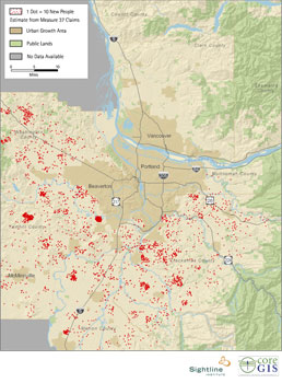
Portland has long been a national model for managing growth while preserving farms and open spaces near cities. A few months ago, we produced a map showing how Measure 37 threatens Portland’s legacy. Now, we’ve updated the map based on new data—and we’ve added a few touches to make it clearer.
In this map, each red dot represents 10 new people based on active Measure 37 claims.
Bigger, better maps of Portland can be found here, and all the measure 37 maps here.
In the counties on this map, more than 2,000 claims for new housing are active. Together, they set the stage for nearly 14,000 new housing units and 34,000 new residents, almost all of them are outside of Portland’s growth boundaries.
Here are the numbers, by county:
| county | active housing claims | new dwelling units | new residents |
| Clackamas | 685 | 4,678 | 11,472 |
| Marion | 398 | 2,951 | 7,482 |
| Multnomah | 81 | 270 | 603 |
| Washington | 642 | 3,865 | 9,533 |
| Yamhill | 246 | 1,914 | 5,050 |
*Sharp-eyed readers will notice that Marion County also appears on the Willamette Valley map and corresponding blog post.
Thanks to CORE GIS for maps and analysis, and to Deric Gruen for the legwork.


