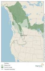
As part of our research on wildlife, Sightline monitors the population of the Selkirk caribou herd, the last population of caribou to venture south of the Canadian border. Last year, we even created a map showing the historical range of North America’s mountain caribou, and compared it to their much-diminished current range. (It’s on the left; a bigger version is here; animated version here.)
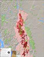
Our map gives the continent-scale picture, but now the good folks at the Mountain Caribou Project have produced a new map with incredible local detail for the British Columbia Rockies (the cartography is by Miistakis Institute). Their map is a fine-grained look at just how fragmented and precarious are the Selkirk caribou and their similarly-endangered brethren in the Purcell Range. Same goes for most of the caribou along the spine of the Canadian Rockies. (A small version is on the left; a much bigger version is here.)
While US mountain caribou are now all but extinct, British Columbia’s caribou are facing a barrage of threats, the most serious of which is unsustainable logging. (See, for instance, Sightline’s maps of BC’s vast clearcuts in the Rockies: here and here. Animated versions are here and here.)
So kudos to the Mountain Caribou Project for their skilled mapping of vanishing habitat. I’m hoping it’s a wake-up call for BC to provide sufficient protection before the caribou make like their cousins south of the border—and disappear forever.
Cameron Eddy
This just goes to show how uneducated people are on the subject. Although most snowmobilers want more room for recreation, many of them are not so selfish as to knowing push an animal to extinction.