2007 update: Inspired in part by this post, a Sightline friend/tech whiz created Walk Score, an online tool to explore and score your neighborhood’s walkability. Check your score and comment on it !

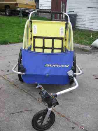
The kids have long-since outgrown the thing. But since we decided to experiment in car-less living, we’ve resurrected it to haul groceries, library books, and (recently) a broken vacuum cleaner.
The Burley’s range is only as far as you want to push it. And for my family, that limit seems to be about one mile. Less than a mile is a comfortable walk; more is a burden. (To extend the range, we can fit the Burley to a bicycle—on which, more another day.)
A one-mile perimeter, therefore, defines this car-less family’s pedestrian travel zone—call it our “walkshed.” Fortunately, because we chose to live in a compact community, our walkshed turns out to be well stocked.
We can stroll to scores of shops and services—248 to be precise. I know because I counted. You can, too, in less than 60 seconds. I’ll tell you how in a moment.

We’ve got pairs of independent booksellers, thrift stores (we know them well), and bakeries (ditto). Three pharmacies, three yoga studios, and three video stores offer us medication, meditation, and mesmerization, respectively. Five grocers and six dry cleaners compete for our appetites and our wrinkles. Nine barbers eye our locks. Dozens of specialty shops hawk their curiosities in the range of our Burley: one sells only flags, another only gifts from Norway, a third only old magazines.
True coffee houses number six, only one of them a Starbucks (which, because it’s so low, may be the most surprising number in this tally). Restaurants? We’re provisioned with 54! (And there are 151 within two miles: we’ll walk farther for great eating.)
Two neighborhood ice creameries are counteracted by an astonishing 42 dentists (none of them covered by our insurance, sadly). Two local smoke shops are outnumbered by an even more astounding 74 doctors (again, not covered by our insurance). And then there’s our one neighborhood orthodontist: he has straightened or is straightening all three of our kids’ teeth, for which we’ve paid him enough to buy three used Volvos or most of a new Prius.
I should perhaps note that, despite these large counts, we do not live downtown. Far from it—-in fact, five miles from it. Our neighborhood of Ballard is a typical streetcar community developed largely in the 1920s and replicated in every North American city of similar age.
I should also probably note that our neighborhood is definitely not Mayberry. It’s got 44 auto shops, 10 taverns, and a liquor store. Oh, plus two sex-toy shops and two strip clubs. (Or so the signs say—I’ve never been inside. I swear.)
All of these counts I did in my head or using the yellow pages, and you can do the same for your home if you live in the United States. Here’s how:
To get the a fairly complete count of businesses, go to this Qwest online phone directory, select the business listings, type “all” in the category field, click “near a street address,” type in your address, and choose “1 mile.” (Sorry, Canadians, I have yet to find a .ca that performs this trick.) If you’re lucky and the database gods are smiling on you (the site is temperamental), Qwest will promptly reveal how many businesses there are within a one-mile walk of your front door. Call this your Walkshed Index, your Burley Score.
Ours, as I said, is 248. There are two hundred and forty eight places where my family can do business within a mile of home, not counting public facilities. That number is not remarkably high: the walkshed index at my downtown office address is 6,623. Nor is it remarkably low: one suburban family I know has a score of 0. But it means that living car-free is more viable for us than it would be for many families.
What’s the Burley Score where you live?
P.S. More than one quarter of car trips in the United States are shorter than one mile, as we noted in Seven Wonders. One quarter!
P.P.S. Realtors provide detailed information to prospective home buyers on schools and resale values. They could as easily report the Walkshed Index—-high scores translate into thousands of dollars of potential savings in fuel and car payments.
P.P.P.S. According to one map-making friend, creating walkshed maps and yellow pages would be a relatively simple Google Maps “Mash Up.” Anyone know of such a tool? Anyone volunteer to do this project? I’d love to have a detailed map stowed in the “glove box” of our Burley of all 248 businesses in my home zone. (I can get close with the Qwest online directory, plus the cool mapping tools at Map24, Google Local, and Windows Live Local. But these tools are designed for car drivers, not walkers.) Ideally, I would want a walking map or PDA application that shows me the whereabouts of public restrooms, water fountains, bike racks, curb cuts, bus stops, and benches. Besides, the Qwest tool is clunky and imprecise. (My total score of 248 is inexplicably less than the sum of all the categories of establishments listed above!)
Update: A reader points out that Canada411.ca will calculate a metric version of the Burley Score. Leave “category” blank, choose 1 or 2 kilometers, enter your address, and you’re set. I calculated a 2-kilometer Walkshed Index of almost 7,000 for an address in Vancouver’s West End. Also, in comments on
our old server, are notes on alternative mapping options such as Yahoo, Mapquest, A9, Super Pages, and Citysearch. Each has its pluses, but none provides
the walkshed mapping tool of my dreams.
2007 update: Inspired in part by this post, a Sightline friend/tech whiz created Walk Score, an online tool to explore and score your neighborhood’s walkability. Check your score and comment on it !


Alan Durning
There’s a whole slew of comments at the old home of this blog.
Elisa Murray
Alan, for some reason I can’t seem to make the Qwest search work for me; it keeps including surrounding areas. When you get a sec, maybe you could help?
Elisa Murray
Hey, anybody from the Portland area who wants to share their story about living car-free and whether this series inspired them? A reporter from Portland is looking for stories.
jillianharrington
Check out Google Earth! I recently downloaded it to my computer, and you can check off types of businesses that you want displayed, like coffee shops. Just zoom in on your location, and it will show everything that you’ve selected around you. Great for those of us living car-free lifestyles.What I would love to see next is something like the google driving directions, but for walking – I walk everywhere, but not everywhere is walkable (some streets have no sidewalks, perhaps one street is so busy it is uncrossable).
MalaMaker
I have been living without a car for the past 7 months. Of course I live in downtown Seattle, so that makes it easier but I am committed to going as long as I can without buying a car. If I need or want to leave town for some reason I can always rent a vehicle for the weekend, but other than that I can do everything via the Metro bus, train or my feets! Even grocery shopping with two sturdy canvas bags and a backpack is doable on the bus. Yes it takes more time, effort and planning but it is certainly not impossible.
Gretchen
This is fascinating! I also live in Ballard with a 233 result at Dex. I’m moving to Lake City where I’m disappointed to find my result is 81.The discussion has moved away from the appropriate distance, and we really can agree to anything as a measure or rating, but I still want to add something to the mix. One doesn’t always have to go round trip. I often get off my bus at Market Street, run an errand, and walk home the rest of the way. I measured it with Yahoo maps at .6 miles. I’m a bit embarassed to say that I wouldn’t walk much further on a regular basis, not in the dark and rain anyway. Ballard Market is just under one mile from home and I did walk home from there Tuesday – I guess I’ll do it for abundant berries and cherries. So to get back to my point, I have probably only walked to my one-mile boundary and back when I’ve been unemployed and had plenty of time, whereas I’ve walked home from Market St. countless times.I think you can go further if you are with friends or family, then it’s a social event as well.
Pukegreen
For Canadians looking for an alternative to the phone directory mentioned in this story, try yellowpages.ca. Click on “Proximity Search” beneath “Find a Business”. Leave the first field empty, choose a range (2 or 3 km is a reasonable walk) and then enter your address. Results are displayed with the closest first.This is a great series of articles—I’ve been car free in Toronto since 2003 and so far the biggest surprises are how little it inconveniences me, how much money it saves, and how adamently most people cling to their cars despite so many obvious negatives. It seems cars have evolved beyond being practical tools into symbols of wealth and independence, and they have a strong grip on our society that will be tough to break.
Kathryn Moogk Maly
I love the idea of a walkshed index. I came out at 445 atop Capitol Hill—17th and John. Though I love to ride my bike, I feel safer (traffic-wise) walking in my urban neighborhood.
blanspery
Wow, I was amazed that even in Boise I came up with 1382 businesses within a mile. And they say there’s nothing to do around here!
jennifernb
Alan-Have you tried Vindigo? It is a PDA application/city guide that includes walking directions, maps, shops, services, restaurants, movie times, art exhibits, public restrooms (and not necessarily public but available restrooms), etc. I have used it since a trip to NYC 2000 back when it only served NY. Now it covers many cities. It was originally free but now I think I pay maybe about $24 annually. I can change the cities I want it to sync on my PDA at any time. I love it! PS – with users able to sync new information, etc. it is generally more up to date than any published guidebook!www.vindigo.com
Alan Durning
No, I’ve never tried vindigo, nor heard of it. I’ll take a look.Readers—test it out an share your review. Is this the walkshed map we’ve been dreaming of?
PatF
Vindigo doesn’t include Tacoma, and dexonline is marginally useful. It included places i know are closed, and didn’t include some that i know are open. The best results were from slogging through Google maps one category at a time. So far i’ve come up with a 1-mile score of 107. The variety of retailers and entertainment venues is very impressive. I agree with Gretchen that an ability to batch errands is helpful when taking the bus. I use a large, undivided backpack and just keep dropping stuff in there as i transfer from one bus to another after an appointment that takes me out of my neighborhood.
Anonymous
Dex tells me our walkshed index is only 115, so I conclude that those 115 businesses must be _especially useful,_ since we live car-free in our inner-SE-Portland home with pleasure and ease. This is a great tool! I already use the term “foodshed” and “walkshed” makes a wonderful addition.
randywestin
ESRI.com (not be confused with ESRI.org) is the Microsoft of Geographic Information Systems- the technology, I suspect, behind Gogglearth.Here’s the blurb from their webpage:”Welcome to ESRI and the GIS community of people who are making a difference in our world. GIS has evolved into a technology that can help people plan, design, engineer, build, and maintain information infrastructures that improve our everyday lives. We believe that ESRI’s GIS technology will empower you to build applications that Make major contributions to our global society. Improve our methods for scientific research and analysis. Make better decisions and consider problems in a holistic way. Using GIS is about sharing what you know and setting new courses that will sustain our world in the years to come”. Happy mapping!
btvs
If there’s a way to do a search for “All” in the newly-designed Qwest site, the method escapes me. It seems to insist on categorical searches only.
Leigh Sims
Unfortunately, it looks like Qwest recently changed the way their database works in the new site design. It’s no longer possible to get any meaningful results for businesses for one mile from an address using “all”, or other generic terms. So for the time being, we won’t be able to get our “walkshed” scores. Sightline will update you if this changes!
daviddamoore
The Qwest method certainly doesn’t work for me now – though I doubt the usefulness of this anyway. I have found that where I live (Sunnyvale, CA), even close-by businesses can involve a death-defying cycle over the freeway, whereas further away places (such as the farmer’s market in Mountain View) can be relatively pleasant to get to. Since ditching our car 5 months ago (donated to charity) we have been totally car-free and feel much better for it. While we deliberately chose to live close to where we work, we have found that you discover places much more quickly on foot or on bike, and that it is actually easier to get errands done without worrying abour parking etc. We bought a bike trailer that is perfect for going to get groceries and running other errands. We even moved house using it (rented a truck for the few very large items like couches).We have had to cut back on making day-trips to places like Santa Cruz (still very viable to make a weekend trip there though), but it hardly seems worth the expense (both personal and environmental) to maintain a car just for things like that.Wonderful to know that there are similar things being tried! The mayor of Palo Alto also seems to be onto the car-free thing!
aryastark
I try to use alternative transportation as often as possible. When I have to drive, carpooling or finding a bunch of errands to be done in the same area of town to help cut down on my amount of driving is always good. My friends at Red Deer Plumbing gave me some great eco-friendly tips too. Remember to turn off your tap while you brush your teeth!
Tyson Cartier
Thanks for the info. There is a great transmission company in Calgary. Luckily, they know how to work with cars because I have no idea about them.