After a string of high profile derailments and explosions, communities across North America are rightly concerned about the risks of an oil train explosion. Railroad workers generally do an excellent job of moving cargo through cities without incident. Yet accidents do occasionally happen; and in an era when a derailment might lead to a deadly explosion in an urban area, it’s worth understanding the risks more thoroughly.
So to get a better sense of the threat to local areas in the Northwest, we investigated accidents reports submitted to the US Federal Railroad Administration (FRA) to map every derailment in the Northwest from June 2011 (when regulators began requiring railroads to report the exact location of mishaps) through December 2013. Here they are:
Our map shows 81 derailments in the first half of 2011 (yellow); 95 in 2012 (orange); and 100 in 2013 (red). You can zoom in, scan, and click on the markers to find some basic information about each of the derailments.
In all, we mapped 276 reported derailments in the region shown above. Over the 31 month period we tracked, the region saw an average of 8.9 derailments of freight trains each month—roughly one every three-and-a-half days.
Many of these derailments were relatively low-stakes affairs in switching yards or at slow speeds, but others were high profile and worrisome. For example, in the summer of 2012, a coal train derailed near the eastern Washington town of Mesa, spilling 31 carloads of coal. And in December 2013, an oil train derailed and exploded into a towering inferno near Casselton, North Dakota.
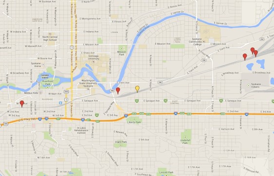
Here’s a zoomed-in look at freight rail accidents in Spokane, Washington:
And Portland:
And the Puget Sound region:
And a closer look at Seattle:
John Abbotts is a former Sightline research consultant who occasionally submits material that Sightline staff turn into blog posts.
Methods and notes. We obtained derailment data through queries of the US Federal Railroad Administration (FRA), Office of Safety Analysis public database. Our data refer to the period starting with June 2011, when the FRA began requiring latitude and longitude to be provided on accident reports, through the end of 2013. Queries were for derailments in FRA Region 8, which runs from the Pacific Northwest to the Dakotas. We omitted derailments in Alaska, as well as derailments of passenger trains.
Our map includes all derailments reported, including derailments in rail yards as well as moving trains. We entered the latitude and longitude coordinates as provided in the accident reports. In a few cases, the coordinates seemed clearly wrong (e.g., located in Canada) and we adjusted these few to be consistent with the County location reported.


