Compared to the noise about congestion from a basketball arena in Seattle’s SoDo district, there’s an eerie silence when it comes to congestion from coal trains there. Yet coal trains would almost certainly create traffic problems in SoDo and elsewhere, with potentially serious consequences for Seattle’s manufacturing and industrial businesses.
The proposed coal export terminal near Bellingham would add 16 loaded and empty coal trains per day, if operating at full capacity. That’s according to the project’s proponents, although my calculations, based on typical coal train volumes reported by the industry, suggest that it would be more like 19 trains per day.
Coal trains can easily be 8,000 feet long, which means that it takes more than 6 minutes to clear a street crossing when traveling at 15 mph, a pretty typical speed in an urban area. Then factor in 30 seconds of street closure time for warning signals to sound or crossing arms to stop traffic, plus 30 seconds to re-start traffic after the train has cleared the intersection. Add it all up and you get this: Bellingham’s new loaded coal trains would completely cut off street intersections by somewhere between 105 minutes and 125 minutes of every day.
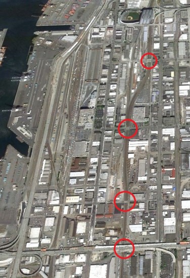
That’s a problem for SoDo, which has four at-grade street crossings of the main rail line. Here’s a look at Seattle’s prime industrial land between SafeCo Field and Spokane Street:
Let’s examine those streets, going from north to south:
- South Holgate Street – Classified as a “major truck street” by the Seattle transportation department, Holgate’s rail crossing sees about 7,000 vehicles per weekday. Holgate has four lanes (two in each direction).
- South Lander Street – The rail crossing sees about 17,000 vehicles per weekday on its five lanes (two in each direction plus center turn lane.) It is signalized.
- South Horton Street – A minor street with two lanes (one in each direction) that seems to provide access to a small number of businesses. The crossing is signalized, but traffic volume data is not reported by the city.
- South Spokane Street – Not to be confused with the Spokane Street Viaduct, an elevated roadway that runs overhead, S. Spokane St. has five lanes (three lanes running east-bound, and two lanes running west-bound). The crossing is signalized and though the street appears to carry heavy traffic, I was unable to locate precise data from the city.
Each of these streets would be effectively closed off by coal trains for around two hours every day. And that’s in addition to existing rail traffic there.
It’s important to note that while coal trains would periodically close off major streets in SoDo, they would not necessarily impede connections to the seaport, at least not directly. Port freight can use elevated streets like Edgar Martinez Drive near Safeco Field or the Spokane Street Viaduct. But for Seattle’s heavy industry and manufacturing base that relies on surface streets, coal trains could pose a real traffic problem.
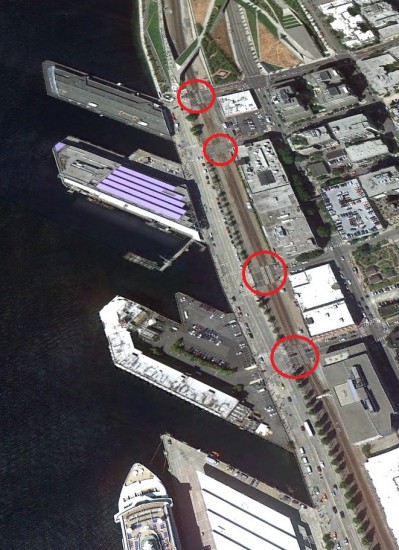
And there’s more to the story. North of downtown, the city has four additional at-grade rail crossings where congestion is already routine. Here’s a look at the stretch of the waterfront between the Olympic Sculpture Park and the Port of Seattle’s cruise ship terminal:
Just as in SoDo, new coal trains would close off Broad, Clay, Vine, and Wall Streets for around two hours per day—and that’s in addition to times they’re already shut off by trains. (Plus, those figures assume that the trains are moving at 15 mph, which is probably unrealistic in that location. At a more realistic 10 mph, they would shut down the streets for between 153 to 183 minutes of every day.)
Fortunately, these at-grade crossings are not currently classified as major freight routes, but their closure would almost certainly amplify congestion in the nearby Western Ave and Elliott Ave corridors. Worse, train-related congestion on the northern waterfront could easily be compounded by the reconfiguration of SR 99, which will divert traffic onto surface streets owing to tolling and the route’s new configuration. Add in seasonal traffic serving the cruise ships, and you have a recipe for severe congestion problems.
I should point out, before someone objects, that it’s theoretically possible to route empty coal trains across Stevens Pass, thereby avoiding Seattle on the return trip. (Loaded coal trains apparently can’t handle the mountainous grade.) But the possibility is only theoretical: the Stevens Pass rail line is already maxed out with rail traffic. So even if returning empty coal trains went over Stevens, they would just displace other trains into Seattle.
It might be one thing if the coal trains were producing a tangible economic benefit for Seattle. After all, it’s perfectly reasonable to accept some level of traffic impairment in order to provide local jobs, freight access to the port, or support the city’s industrial base. But the coal trains have virtually nothing to offer Seattle except delay and pollution. They will connect a handful of mining jobs in Wyoming or Montana to a handful of railroad jobs to a relatively small number of jobs at a port site near the Canadian border. But at what cost to jobs and businesses in Seattle and other cities along the way?
We know that coal trains could close streets for around two hours of every day, 7 days a week, 365 days a year—that’s just arithmetic. But how much traffic congestion will that cause? And how big will the problem be for freight? We don’t know.
To the city’s discredit, we do not have an updated freight mobility plan for Seattle. And the existing freight transportation planning documents do not account for the huge projected increases in coal train traffic.
That’s a problem. And it’s a problem that Seattle’s freight community should take a keen interest in.
Postscript: My analysis here is necessarily abbreviated. Interested parties would do well to examine the recent work done by Gibson Traffic Consultants. Gibson provides a detailed and quantitative look at traffic impacts in Seattle and several other cities, and the Gibson analysis demonstrates that coal trains pose a meaningful threat to local freight traffic.
More of Sightline’s analysis of coal trains here:
- Coal Trains and Rail Congestion
- How Coal is Already Congesting Washington’s Railways
- The Life Story of a Coal Train


Comments are closed.